This entire document is a work in progress, and very little work has yet begun to implement the standards
described herein. Detail discussed may be removed or superseded without warning; you are advised to follow
issues relevant to your work in this list
until this document is stable.
Motivation and background
Networks of urban sensors are increasingly prevalent. There are many uses for these devices connected to the
Internet of Things, such as sharing car park occupancy, pollution management, weather forecasting, public safety,
and reactive traffic systems.
There is a need for a standard that focuses on extensibility, reuse of established standards, and is
comparatively trivial to implement as a layer on top of existing software and services. The ontologies and
vocabularies recommended are selected because of their relevance to real-time sensor networks, and their
ability to be used alongside related standards such as PAS 180 and ISO/IEC 30182:2017, descriptions of the
built environment in [[IFC]], or [[CityGML]], or elements of JSON Schema and OpenAPI to create services and
web applications.
This document presents a proposed standard for publishing federated networks of sensors and services,
focusing on mechanisms for discovery, obtaining real-time and historic data, and contextual data. It
does this primarily by clarifying the use of existing standards, resolving ambiguity and omissions for
implementation detail, and providing detailed examples. These combined create a linked federation of [[REST]]
APIs, enabled by standardised hypermedia.
Maturity
The maturity model comprises different levels that ultimately facilitate data integration across different
domains, systems and data models. The aim of this standard is to achieve level six and move closer towards
seven.
Data only available through propreitary interfaces
Data available using a single data model and domain-specific interface (e.g. SIRI)
Data available using an HTTP(S) API with developer-focused documentation
Data available using a publish-subcribe model or real-time stream
Data available using a [[REST]] API with a recognised hypermedia suitable for generating user interfaces
and client-side validation
Data accompanied by relevant context, such as links to geographic entities in other systems
Data is fully discoverable by automated means
Data is fully filterable, searchable and traversable and comprehensible by automated means
Principles
This standard has been prepared to satisfy the following general principles.
It MUST be possible to discover sensors in different cities and disparate systems by following sequential
links from a single national or international entrypoint.
Data SHOULD be accompanied by links to relevant contextual
information, through machine-readable hypermedia, and appropriate ontologies and vocabularies.
Options for extensibility SHOULD be maintained and able to coexist within a single system, such as
provision for controllers and actuation, data provenance, and the use of non-sensor but otherwise related
ontologies.
Implementation MAY take any form (i.e. any sensors, any database, any underlying communications protocols),
provided the output and interface conforms to the standards herein.
Entities including sensors MAY be partitioned across multiple APIs, with two-way links.
This standard SHOULD be reuse existing standards, except where no viable option exists, or two
standards are incompatible. It SHOULD be possible to integrate data published with this standard with
a wide range of other systems and practices.
Conformance
As well as sections marked as non-normative, all authoring guidelines, diagrams, examples, and notes in this
specification are non-normative. Everything else in this specification is normative.
The key words MAY, MUST, MUST NOT, NOT RECOMMENDED, OPTIONAL, RECOMMENDED, REQUIRED, SHALL, SHALL NOT, SHOULD,
and SHOULD NOT in this document are to be interpreted as described in BCP 14 [[!RFC2119]] [[!RFC8174]] when, and
only when, they appear in all capitals, as shown here.
Data SHOULD be provided under a licence compatible with the Open
Definition unless there are overriding reasons, such as personal data or the IPR resides elsewhere.
Architecture
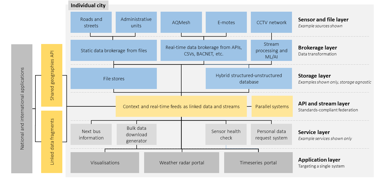
A federated approach is adopted.
The figure below shows the generalised architecture for a federated network of sensors and services.
Implementation details such as the choice of database, sensor hardware, and communications
networks shown in blue are outside the scope of this document; implementations are free to choose these
details and use any appropriate technology or codebase.
Architecture for an (inter)national network, linked through shared standards
and registration of sensors against shared geographies
Implementations MAY poll data directly from sensors and transform data in real-time, provided the eventual
output is conformant to this standard. Implementations MAY also provide eventual consistency, or separate
the archival of historic observations from the access to the latest observations.
Application programming interface (API)
Transport
Serialisation
Hypermedia controls
Use of query parameters
Collections and filtering
TODO: Write some text here.
Spatial selectors
TODO: Write some text here.
Parameter
Description
proximityCentre
MUST be used in combination with proximityRadius. Sets the centre of a circular or
spherical bounding area depending on whether height is specified. Only resources within the spatial
area are returned.
Uses the format: longitude,latitude,height. Height is optional. Longitude and latitude use
WGS84. Height is in metres.
proximityRadius
MUST be used in combination with proximityCentre. Sets the distance from the
proximityCentre in metres.
Sub-selectors
TODO: Write some text here.
Condition modifiers
TODO: Write some text here.
Possibility of additional modifiers __in and __begins still under discussion.
Pagination
TODO: Write some text here.
Authentication
Structures, ontologies and properties
Sensor networks and observations
Platform
Sensor
Observation
Sampling
Result
Deployment
System
Feature of interest
Procedures and provenance
The [[vocab-ssn]] ontology provides alignment to the PROV ontology. Should we provide an example of how
to do that?
Geography
Alignment to GeoJSON
Creating a valid GeoJSON output will require a properties key in the object. This should be
an optional approach for APIs that want to produce valid GeoJSON, by using JSON-LD nesting?
Collections
Observation collection
Response metadata
Pagination
Vocabulary
Classes
Handling of collections and views on collections is yet to be finalised.
Disciplines
List is yet to be finalised.
Observed properties
List is yet to be finalised.
Units
List is yet to be finalised.
Discvovery
Shared geography
The proposal here is to have a national geography API and delegate authority to each city to be able to
register sensors against.
Linked data fragments
This is a way of allowing complex queries such as SPARQL against the data, without having to run a full-blown
SPARQL database and exposing it to the world. The problem with exposing SPARQL endpoints and hitting them
with POST queries for example, is the response cannot be cached. It does not work well with HTTP. Linked
data fragments don't have this problem.